| CARVED IN STONE.us |
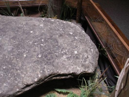
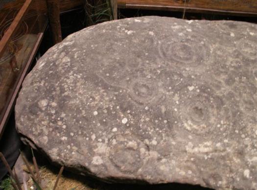
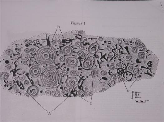
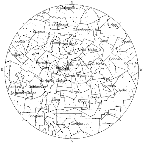
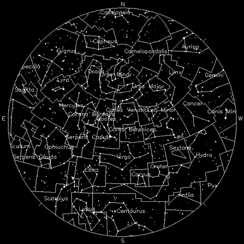
The Reinhardt University Rock Star Chart, Ancient GPS Locator and Map Maker Location: Waleska, Georgia Interpreted by Tom Cox With illustrations and Photos ====================================== When white men began to flood into Cherokee lands in the early 1800’s, they became aware of many rocks with ancient strange carvings on them throughout the Cherokee Nation, which included North Georgia. It was mostly “gold fever”, a disease peculiar to the European mind, which brought them to the area and a “get rich quick” mentality, which drove them to steal land from the Cherokee and destroy many of the rock carvings of the area, removing them, destroying them with the misguided idea that Desoto, on his gold searching exploits through Georgia in the 1540’ s had hidden gold under these rocks. Others thought the Cherokee, knowing the whites and their reputation for gold greed, had buried their gold under these “markers” . The Reinhardt Rock was one of the victims. In the 1940’s, the Cline family, owners of the land on which the Reinhardt rock originally rested, donated the petroglyph to Reinhardt University and had it moved to the campus. Today the rock is the centerpiece of the Hall of Ancients in the Funk Heritage Museum, adjacent to and a part of Reinhardt University. The Funk Heritage Museum features the history of North Georgia with a focus on the last 200 years and chronicles the life of the Cherokee people, their forced removal and illegal takeover of the area by invading whites. The life of those early white settlers is also featured. The existing rock was supposedly one of three carved rocks found at the same site atop a high ridge overlooking the Etowah River, a known “highway” in earlier times. The original site is now part of the Keithsburg Community and is about 3 miles north of Canton, Georgia. Analysis and Interpretation Though early witnesses say there were three rocks, our analysis of the Reinhardt Rock revealed that it was the center of a larger singular rock with two sides having been broken away from the surviving center. This could have happened naturally by earthquake, or by white men blasting the original larger rock looking for gold. Regardless, the Reinhardt Rock was, at one time, part of a larger rock. Evidence for this can be observed by looking at each of the long sides, where obvious break-a-way cleavages can be easily seen. The second, and most compelling evidence, is that petroglyphs on both sides where the breaks occurred are interrupted. Had this been a singular rock, complete in itself, these interruptions would not have been consistent from top to bottom. There is evidence that some of the carvings have been sheared off, possibly by collectors, similar to the fate of Track Rock near Blairsville. Our interpretation of the rock is that it is similar to other petroglyphs we have analyzed and interpreted in the South. It is a star chart of North Georgia skies and possibly a solstice measurement device. Photo: The Reinhardt Rock aligned to North and showing the broken-off right side of the rock. The opposite side is also broken-off. I also know this because the star constellations like “drago” and others are interrupted by the breaks Photo: The lower or Southern end of the the broken rock showing partial constellations The goal of our explorations, analyses and interpretations is to find and make known evidence that Mediterranean and European people were here more than 3000 years before present day. (Please, visit the interpretations of these and other similar sites on our web site: www.carvedinstone.us: particularly, The Tugalo Stone and Fort Mountain) The Reinhardt Rock is a section of a map-making device showing the North Georgia night sky. It probably was a solstice measuring device, as well. Earlier researchers carefully copied all the symbols on the rock. The darkened symbols were made earlier as part of the “copying of the sky” charting of the constellations. Early visitors from Europe, Africa and the Mediterranean, where they were familiar with the Northern Hemispheric skies, saw a different night sky than they would see in North America. Some stars and constellations would be the same, some would have moved off the horizons, some new appeared on the opposite horizons. Early visitors here needed new navigational reference points as they traveled the Americas. Certain universal symbols of objects in the night sky were used in early navigation. The most important symbol for celestial orientation is the “X” within a “circle”-Polaris-the North Star and is the most important “marker” on any old map. The North Star is the only star in the Northern Hemispheric sky which does not move. All other stars revolve around it, thus, its value for orientation. Photo: on the Northern end of the rock, a carved Circled “X” orients the observer to the constellations on the chart. The major northern hemisphere constellations can all be found, some in part due to the broken rock. The Constellations, “Big Dipper” and “Cassiopeia” point toward it as they continuously circle it. Polaris is the most dependable night -navigational aid. The symbol for Polaris, The North Star, is prominent on the Reinhardt Rock. Looking at the rock as you enter the “Hall of Ancients,” look for the circle “X” toward the right, approximately one foot from the edge, in the lower middle. Conversely, the sun is the most important by day, which is why solstice sites are also important, not only for seasonal measurements and “Ra” (sun) worship celebrations of the solstices and equinoxes, but, also for navigation. The ancients’ ability to navigate was nearly as accurate as our GPS, today. I built a miniature “Stonehenge” on the western- facing bank on the Georgia Island on which we lived. After the first annual cycle, I could tell you what day it was and locate true north without any other navigational device. We “moderns” tend to think no one before us had the knowledge we now have. The truth is, the dark ages wiped out enormous knowledge that we have had to “re-discover”. To further show that the Reinhardt Rock is a Star Map, I referenced the night sky celestial star chart from www.fourmilab.ch/cgi-bin/yoursky and “tuned in” Atlanta’s night sky in August 2010. I located the North Star dutifully hanging in the Northern sky. It is the last star in the Constellation: Ursa Minor. It is easy to find it at night. I look for either Cassiopeia (The “W”) or “The Big Dipper” (part of Ursa Major), (which ever is “up”, sometimes both are.) The easiest way to locate the North Star is to draw a line along the lip and front vertical side of the Big Dipper cup outward from the lip side. That line runs into the North Star. It isn’t the brightest star, but it is always there in the same dependable place. I copied that star map and observed to see if any other stars “fit” in, especially Ursa Minor. UM was there, but it was backwards. I then “mirrored” (reversed) the same star map and looked again. There was The North star: Circle “X” at the end of a complete Ursa Minor. Then, I saw the massive, long reaching Constellation “Draco” with its long tail reaching around Ursa Minor. The two larger “pocks” with rings are the two brightest stars in that part of the sky and are the anchor of Draco. (see the photo of the South end of the rock above) The more rings around the “pock”, the brighter the star in the night sky. Parts of the Big Dipper are there, too, but broken off. This supports my hypothesis that the Reinhardt Rock was once a much larger, more complete rock, Map-making star chart. The map-making technique used in that day and today by artists, was to make the “negative” carved into a hard surface, that is, the carving is executed “opposite” of what the map-maker wanted as the final result. Once completed, wet leather or other “shrinkable” substance, which can be dyed, colored or written onto, is placed onto, or around the rock “negative”. Animal skins and Papyrus are examples. Paper-mache would be an easy substitute today. Once the applied copying material is dried, it is pealed off leaving “positive” impressions on the material. These are then colored, or traced to make a permanent map. It is my hope to find the exact spot where the Reinhardt Rock first rested, then to find the missing pieces and put together a more complete map, history and purpose for the Rock. On most petroglyphs, I find writing, which helps me to date the making and the makers and add another chapter to Georgia’s ancient history. If we believe that these rocks are not just pictures scribbled by what history and archaeology have led us to believe were childlike, ignorant Indians (which they were not) and look for intelligence and purpose in the efforts of these ancient visitors, we will serve our own history well. ============================== Copyright © 2015 Thomas D. Cox, Sr. All Rights Reserved. No information, illustrations, photographs or any other part of this paper may be reproduced in any form without the expressed, written permission of the author. |