| CARVED IN STONE.us |
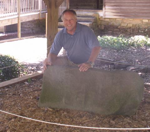
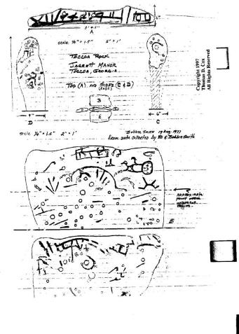
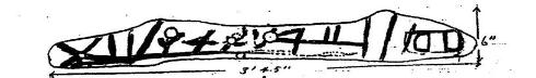
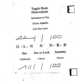
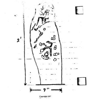
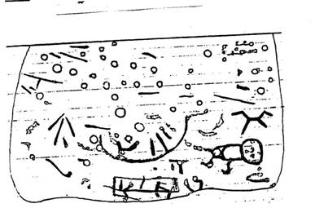
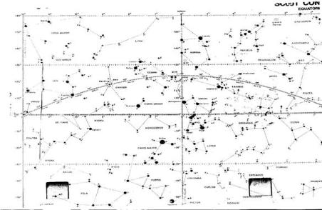
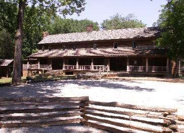
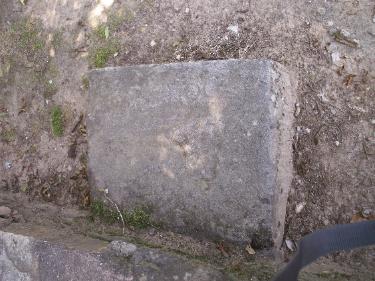
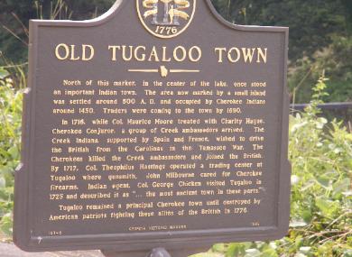
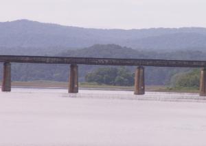
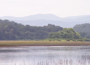
The Tugalo Stone With illustrations and Photos Archaeologist and Petroglyph Interpretor Thomas Cox With the Tugalo Stone ============================== In the early nineteenth century, a white settler in the North Georgia Cherokee Nation built a rest stop for travelers crossing the Cherokee Nation.. “Traveler’s Rest” (Taccoa, Georgia) Built 1814 on the Unicoi Turnpike Travelers’ Rest became a stage coach stop on the old Cherokee-Federal Unicoi turnpike, the first major road through the Cherokee Nation. Owned by the Jarrett family for more than a hundred years, the historic Inn was acquired by the state of Georgia in 1955 and has been restored as a state park and historic site. Jarrett took numerous stones from the Old Tugalo town mound located a few hundred yards away beside the Tugalo River, (which becomes The Savannah River, a direct route to the Atlantic). It was believed that he took only the one stone, which stood out, a gravestone-shaped stone which had unusual carvings on all four sides and the top. (See the photo with the Author above) However, I recently discovered that he took many rectangular shaped stones to form the foundation, steps and walkways of the 1814 Inn. Many had the same carved writing style and languages found on the larger Tugalo Stone. Many white men coming into the Cherokee nation greedily thought these “worked” stones and the enigmatic petroglyphs found on them were Cherokee maps leading to gold and treasure hidden from the Spanish explorer Hernando Desoto who traveled the area in the mid 16th century. Many petroglyph sites in Georgia and the South have been destroyed by gold-fevered white men looking for treasure. Old Tugalo Mound is now an island and located at the foot of the Appalachian Mountains. Travelers’ Rest is located a few hundred yards to the left. The Tugalo Stone, as it has become known, and many other shaped and carved stones were moved a few hundred yards approximately 200 years ago to the Travelers’ Rest site overlooking the river, where the stone, with carvings on 5 sides, remains today. Until recently, it was laying on its side covered with more than a decade of leaves. However, Georgia’s Department of Natural Resources, which supervises the old Travelers’ Rest Stagecoach Inn historic site and park, recognized the stone as having historic significance after becoming aware of my findings and interpretation. It is now preserved under a protective shelter behind the old Inn. I became aware of the Tugalo Stone in the late 90’s through Gloria Farley, a pioneer in proving pre-Columbian European visitation. I visited the Heavener Rune Stone State Park in the mid-1990’s, a site preserved largely due to her efforts and research. As an on-air personality on a Tulsa, Oklahoma TV station in the 70’s, I watched in amazement as our news department did an interview with Gloria on her pre-Columbian discoveries, beginning with the Heavener Viking language stone she researched and proved in Heavener in Southeastern, Oklahoma. Years later, I visited the Heavener State Park, arriving after hours, but thanks to a friendly Park Ranger, I was able to take the tour. I bought her book, In Plain Sight, signed the guest register and within 24 hours had a call from Gloria. I live in Georgia, which she noticed on the register. It led her to ask me to help her find some latex molds she had made of her most important discoveries. I soon located and recovered the missing molds of petroglyphs from a deserted Decatur, Georgia warehouse, returned them to her and we became friends. Learning of my background in history and languages, she asked me to visit the Tugalo site to give her my impressions of what I thought of the stone, which had become an enigma to many researchers, including Gloria, who had visited the stone herself. When I first visited it, I was shocked to find it pushed over and buried under leaves. The park ranger said everyone had lost interest in the stone years before and it had fallen into neglect. The acid created from the moisture and the leaves had made the stone almost unintelligible, but I began to make sketches of what I could make out on the exposed side. Looking over my shoulder, the ranger commented: “That’s very close to the sketches made years ago”. Relieved that someone had made drawings while the images could be seen, he then sold me a book published years before with photos and accurate drawings of the carvings. (Seen as the illustrations here) I bought a copy and headed home to my library and the beginning of an amazing adventure of discovery. The book contained an overview drawing with the six faces of the stone marked as “A” through “E”. “A” The Top of the Rock My first thought was that the characters I saw were “Ogham”, the old Celtic notched form of writing because there appeared to be a stem line. But, the characters were not consistent. Then I recognized one group of characters resembling the Old Celt-Iberian script for the word G-L-N translated “Sun”. I was glad this was the first thing I translated, because, it made me look to see if this was a solstice stone. The script to the right was not Celt-Iberian, but seemed to be Old Libyan, the first of which I translated as “Look” or “See”. The word adjacent to “See” I translated as the Libyan script for “Summer”. I stood back and read: “Summer See Sun”. (Reads right to left) The Tugalo Stone, in its original location on the river and most likely atop the prominent mound. I interpreted this as evidence it was a Solstice Stone pointing toward the sunrise on or about June 21st. There are many Solstice Calendars located all over Europe and the world,and here in the U.S., one of the most notable being Stonehenge near Salisbury in England. Many of us who believe Columbus was a late-comer have found much evidence of visitation, trade and colonization in the Americas, but this was the first I had seen Solstice evidence first-hand in North America. I have since visited, photographed and interpreted many other Southeastern solstice sites. I questioned whether I had jumped to an erroneous conclusion in my zeal for discovery, and awakened my scientific integrity, to consider the possibility that in my excitement, I had imagined this interpretation to meet my solstice theory. So, I looked elsewhere on the Tugalo stone for further evidence to back it up the solstice theory and the obvious intelligence who made the scientific sun measuring instrument before me.. I ask the reader to look now at “C” The narrow face on the right Without a doubt, on this narrow face, I was looking at the ancient symbol for the Sun in motion- “Ra”, the half-circle with a pock in its middle. Had it been a complete circle with the pock, it would have simply indicated the sun, a common symbol all over the ancient Mediterranean and European world, but this was located where the reader of the Tugalo Stone would know to “line up” the rock with the sun’s position. The carving indicated “Ra Rising”, the sun rising. I am fortunate to have lived on a Georgia barrier island on a mile-wide river looking west. There, years ago, I constructed a “mini-stonehenge” at the edge of the water and produced my own “Solstice calendar” where I could predict within a few days, the summer and winter solstices, the spring and fall equinoxes and all the months. The ancients knew this and lived by these calendars and built them wherever needed to predict Seasons, plantings, calving, travel and much more. It could all be planned with accuracy using the sun and dependably repeating movements in the night skies. I ask the reader to now study “D”, the opposite narrow face. Within moments, it occurred to me that the pattern of pock marks under the slash resembled the constellation Orion, but I did not recognize the series of pock marks above the slash. As a Naval aviator I was trained in celestial navigation. I pulled out my book with the star charts and looked “above” Orion to see if I could recognize a star pattern similar to that carved into the rock. I do not remember ever having been aware of the trapezoidal- shaped constellation Auriga, but there is was. My 20th century star chart and the pock marks on this ancient rock were obviously the same. (see star chart below). This modern star chart matches the pock mark star pattern on the Tugalo Stone And then I saw something that, to this day, is the most exciting discovery I believe I have ever made. The “slash” I described earlier, which was cut across the rock separating the two constellations, was right there in front of me again, appearing on my star chart exactly as it did on the Stone. My star chart showed the path of the sun moving through the constellations on June 21st. On the longest day of the year, the sun rises between the constellations Auriga and Orion. They knew it and left it for us to find. Modern science has always underestimated the intelligence and applied knowledge of the ancients. This, to me, was powerful historic evidence. Stone Faces B and E are Navigational Charts/Directions from Europe to the Americas and Back. Face “E” petroglyphs (B & E) hoping and expecting to find more evidence of who these people were and the message they left. But, the shapes were odd, nonsensical, even, child-like with one etching resembling an animal or a doll. I puzzled over this for days. I made transparency copies of B and E and pinned them up on my cork board wall just as one would see them on the side of the rock if one were standing there in the yard at Traveler’s Rest. Frustrated, I took “E” off the wall and tossed it down on my desk. It landed face-up, but inverted and backwards. Suddenly, there appeared to my mind’s eye the shape of a Phoenician style ship, which seemed to be moored at a dock platform. I saw a main mast, a man standing on the deck, the bow, and cabin aft with what appeared to be oars and a steering rudder. Once I believed I was looking at a ship, I realized all the pock mark “stars” were above the waterline. Above the ship was the symbol for “Ra”, the sun, in motion again and the Pole Star, drawn as I had seen it before: a circle with an “X” in the middle, the ancient symbol for the North Star, the only star in Earth’s sky which does not move, but is always in the same place in the northern sky. The Big Dipper’s front edge constantly points toward the North Star as it circumnavigates around it at night. Anytime you want to find “north”, find the big dipper and draw an imaginary line from the front edge of the cup upward from the cup. It will pass through the North Star and give you Celestial North. In this case, the star appears up, away and to the right of the ship, which follows the sun in motion to the west. The big dipper is pock-marked into the stone sky with the front of the cup pointing dutifully toward the star. Why would the carvers etch these images upside down and backwards? “B” Reversed and inverted The big dipper is there again, but this time the cup is pointing the opposite direction from the “E” face dipper. There is also a symbol which resembles the rising sun ahead of the ship. Because these two sides are upside down and reversed on the rock, I came to the conclusion that The Tugalo Stone is an ancient map-making machine, Xerox BC, if you will. We know that maps have been made from leather for thousands of years. The mapmaker carved the lines and symbols backward into rock, or wood, which he wanted to stand out on the map correctly making a positive, raise image. He then would drape wet leather onto the surface. As the leather dried, it shrank into the rock, filling the carved holes and making the leather similar to a “positive”. Then, highpoints were colored with permanent dyes making the map. This explains why the images are upside down and backward. The person wanting to duplicate these instructions would drape his wet leather over the Tugalo Stone, let it dry, color it in and he would have permanent instructions for travel to and from Gibraltar/Africa and back by way of Britain and Europe. I believe the Tugalo Stone is not only a Solstice calendar, but a comprehensive explanation showing how those who left this rock in Georgia got there from the Mediterranean with equally important instructions on how to return. For years it was a mystery to me why the travelers left the stone in Georgia, until I visited the site again recently to take new photos. The Tugalo mound is located at the North end of the Piedmont plain at about 700 feet above sea level. When my wife and I took new photos of the Tugalo Mound, (which now stands in the middle of Lake Hartwell’s backwaters), we realized the backdrop was the first mountains an ancient traveler would encounter as they traveled seeking the gold and copper fields there. The Old Tugalo Town mound, seen framed by the railroad trestle The mound was the “last stop”, the “jump-off point”, much like St Joseph, Missouri was for western pioneers. There are many mounds in the Southeast, most of which have produced artifacts from Europe and the Mediterranean. At the Etowah Mounds in North Georgia, Gloria Farley inspected an amulet which proved to have a Libyan inscription. Compass stones with Mediterranean scripts have also been found in the Southeast. I have inspected other sites in Georgia, North and South Carolina, which state historians claim to be American Indian, which instead are Ra (sun god-Baal) Temple sites, many of which lined up to be Solstice sites, alphabetic characters peculiar to Old Mediterranean and European languages from back to 1000-2000 B.C. and other evidence that visitation was widespread-before-Columbus. I have also proved by metallurgy that copper mined in Georgia and Tennessee was mixed with tin mined in England to produce some of the oldest bronze implements. Historians and anthropologists now know that the people we call Celtic: Irish, Scots and Welsh originated on the coast of Spain-Iberia. It is most likely they were picked up by sea- going vessels from Mediterranean explorers for the journey and eventually made their way across the seas to the first land fall, arriving in the British Isles and settling there, following ancient voyages to the new world. It took satellite weather imagery to reveal to us where and why hurricanes originate, but these world-class sailors knew that winds swept toward the west from the upper coast of Africa beginning in Spring and lasting until Fall. We now know that heated air rises from the Sahara Desert and is then swept westward by upper level winds. These winds would drive the famous Phoenician and other fleets directly to South America, the Caribbean, or the Atlantic Coast. If you left the rock of Gibraltar in the late spring or summer, when the winds begin to move across the Atlantic, and you then followed the instructions on the maps shown on The Tugalo Stone, you would come upon the Americas. We now call this time “hurricane season”. When the travelers would leave the Americas to return, they would follow the return instructions on the map, which told them to follow the Pole Star and continue in the direction of the rising sun. This would take them up the Atlantic Coast then across the North Atlantic to Ireland or England, first, then following familiar coastlines, make their way back to Europe or into the Mediterranean Sea to home. I have deciphered a similar stone map-maker site located adjacent to an ancient “Ra” sun god temple in Spain, which gives the same instructions as The Tugalo Stone about crossing to the Americas. Is it possible Columbus knew of and had a copy of these instructions taken from this site? It would explain his confidence. If he did follow those instructions, leaving Spain sailing south, catching the Westward winds across, he would arrive right where he eventually did. I present one last evidence that the Tugalo Stone was the Map machine I claim it to be: have you noticed that on ancient leather maps, there almost always appears a great fish or sea serpent at the bottom of the map? Look again at the “B” map, at the lower left corner. What appeared to have been a child’s doll or animal might just be the whale you see on other ancient maps. It is ironic that a North Georgia State Park celebrates as history a structure barely 200 years old, while in that same State Park, what might be important evidence of visitors from thousands of years ago lies quietly just behind. For centuries we thought it was just a rock with strange carvings. We know now it is more important than we could ever have imagined. Another Interesting photo appears below. A stepping stone at Travelers’ Rest Inn reveals the Celt-iberian word for “Ra” or “Sun” with an arrow pointing. This is one of many ancient “carved in stone” petroglyphs used in the construction of Travelers’ Rest. Author’s Post Script: I welcome opposing views, new information and interpretation. If you know of other stones with enigmatic carvings or other evidence, please, get in touch with me. If your school or organization would like a lecture or lecture series, please contact me directly, Thomas Cox (706) 889 5990 cell. Or tcox@carvedinstone.us www.carvedinstone. us is a repository and resource for sites, interpretations and evidences, proving visitation, colonization, mining and trading by ancients from Europe and the Mediterranean. =================================== Copyright © 2015 Thomas D. Cox, Sr. All Rights Reserved. No information, illustrations, photographs or any other part of this paper may be reproduced in any form without the expressed, written permission of the author. |
The opposite and other
narrow side of the rock I
discovered to be a star chart
giving the celestial position of
the dawn appearance of the
sun just moments before
sunrise on June 21st, the
Summer Solstice and the
longest day of each year
.
There were many pock marks
on this face with a carved
“slash” beginning from the
lower left and extending in an
arch upward and to the right.
Knowing that I was now
looking at the work of
extremely
knowledgeable ancient
travelers, I studied the
two broad side face
looking at the work of
extremely
knowledgeable ancient
travelers, I studied the
two broad side face
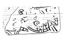
I took down the “B” face
and turned it upside down
and reversed like I did “E”
.
Immediately, I saw another
ship similar to the other.
and turned it upside down
and reversed like I did “E”
.
Immediately, I saw another
ship similar to the other.